Amity Point Shoreline Erosion Management Plan
Consultation has concluded
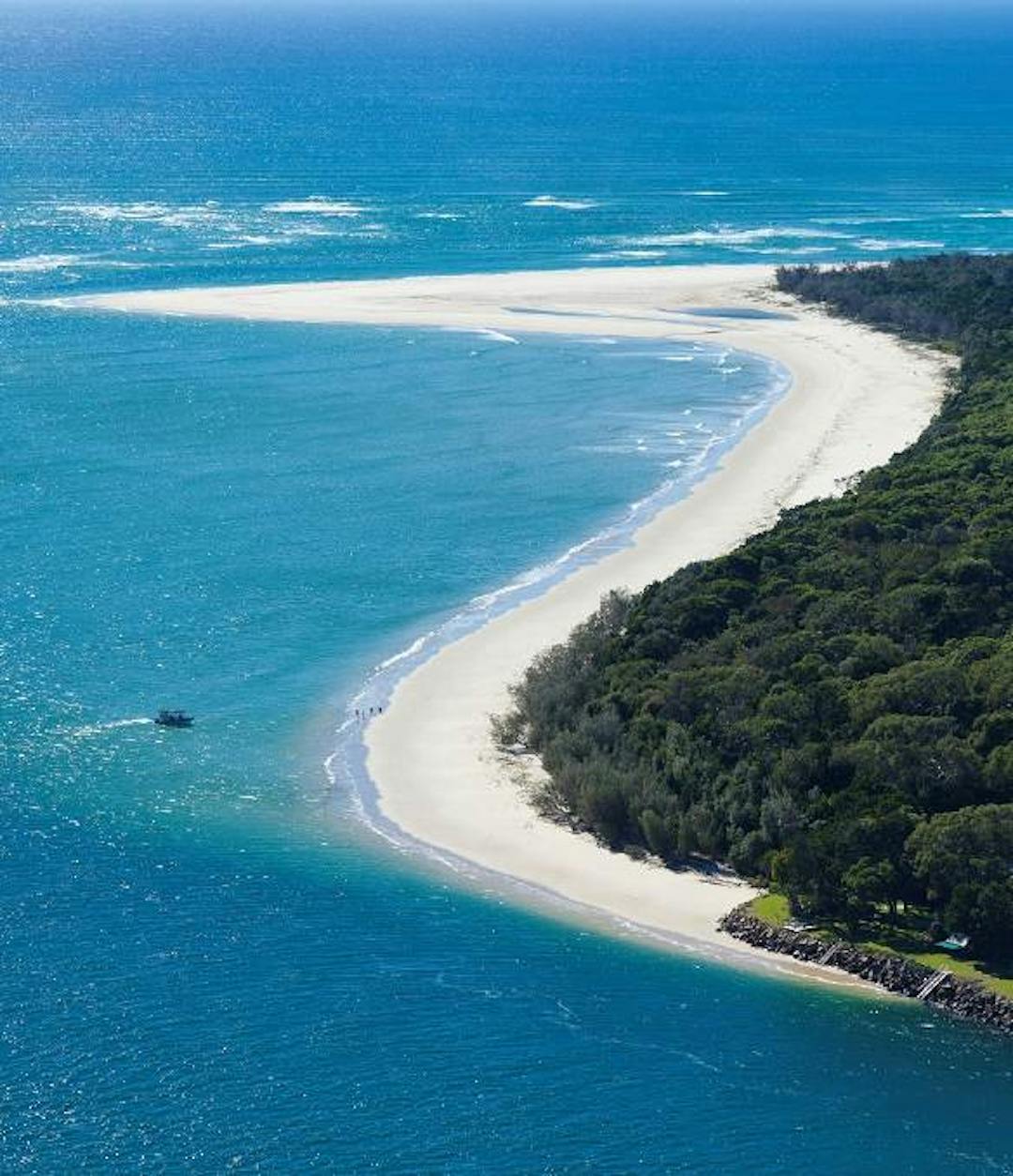
Amity Point (Pulan Pulan) is a small seaside locality on the north-western point of North Stradbroke Island (Minjerribah) situated off the coast of southeast Queensland.
Fronting the calm waters of Moreton Bay (Quandamooka), Amity Point is the perfect place to watch the sunset, admire the native plants and trees, and encounter a range of marine and island wildlife, including dolphins, turtles, whales, and koalas.
The Amity Point foreshore is at risk of long-term erosion due to episodic flow slide events and the southerly migration of the Rainbow Channel located between North Stradbroke Island and Moreton Island.
Amity Point has been declared an erosion-prone area under the Coastal Protection and Management Act 1995 and has a long history of significant erosion, which has resulted in the loss of Indigenous values, public and private land, and assets.
Redland City Council has worked with stakeholders, including Quandamooka Yoolooburrabee Aboriginal Corporation, State Government agencies, private landowners, and the project's Community Reference Group (CRG) to develop a plan known as a Shoreline Erosion Management Plan (SEMP).
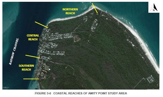
The Amity Point SEMP identifies erosion hotspots in the locality's three coastal reaches and recommends management actions for Council and private landowners to help manage and respond to current and future erosion risks.
What is the Community Reference Group?
The SEMP's CRG represents a cross-section of the Amity Point community and includes representatives from Quandamooka Yoolooburrabee Aboriginal Corporation. The CRG brings together Traditional Owners and local stakeholders to contribute their local knowledge of erosion, as well as the wider cultural, historical, environmental, and economic values of Amity Point towards the development of the SEMP.
The group has contributed by sharing information, insights, and progress reports back to their community networks.
Find out more
- Read the Amity Point SEMP and Implementation Plan located in the 'Documents' section
- Download project fact sheets located in the 'Fact Sheets' section
- Check out the latest project updates
- Learn about other similar projects, like the Coochiemudlo Island SEMP and the Coastal Hazard Adaptation Strategy in the 'Related Projects' section
Amity Point (Pulan Pulan) is a small seaside locality on the north-western point of North Stradbroke Island (Minjerribah) situated off the coast of southeast Queensland.
Fronting the calm waters of Moreton Bay (Quandamooka), Amity Point is the perfect place to watch the sunset, admire the native plants and trees, and encounter a range of marine and island wildlife, including dolphins, turtles, whales, and koalas.
The Amity Point foreshore is at risk of long-term erosion due to episodic flow slide events and the southerly migration of the Rainbow Channel located between North Stradbroke Island and Moreton Island.
Amity Point has been declared an erosion-prone area under the Coastal Protection and Management Act 1995 and has a long history of significant erosion, which has resulted in the loss of Indigenous values, public and private land, and assets.
Redland City Council has worked with stakeholders, including Quandamooka Yoolooburrabee Aboriginal Corporation, State Government agencies, private landowners, and the project's Community Reference Group (CRG) to develop a plan known as a Shoreline Erosion Management Plan (SEMP).
The Amity Point SEMP identifies erosion hotspots in the locality's three coastal reaches and recommends management actions for Council and private landowners to help manage and respond to current and future erosion risks.
What is the Community Reference Group?
The SEMP's CRG represents a cross-section of the Amity Point community and includes representatives from Quandamooka Yoolooburrabee Aboriginal Corporation. The CRG brings together Traditional Owners and local stakeholders to contribute their local knowledge of erosion, as well as the wider cultural, historical, environmental, and economic values of Amity Point towards the development of the SEMP.
The group has contributed by sharing information, insights, and progress reports back to their community networks.
Find out more
- Read the Amity Point SEMP and Implementation Plan located in the 'Documents' section
- Download project fact sheets located in the 'Fact Sheets' section
- Check out the latest project updates
- Learn about other similar projects, like the Coochiemudlo Island SEMP and the Coastal Hazard Adaptation Strategy in the 'Related Projects' section
-
New foreshore survey data available with second planned for early 2023
Share New foreshore survey data available with second planned for early 2023 on Facebook Share New foreshore survey data available with second planned for early 2023 on X (formerly Twitter) Share New foreshore survey data available with second planned for early 2023 on Linkedin Email New foreshore survey data available with second planned for early 2023 linkCLOSED: This discussion has concluded.New foreshore survey data has been produced to assist erosion-affected homeowners at the northern reach of Amity Point. It comes as foreshore monitoring continues with a follow-up survey planned for early 2023. The data gathering forms part of an ongoing coastal process study expected for completion by mid-2023.
Council is providing the survey data and coastal process study to landowners in the northern reach of Amity Point to help them understand and plan around the dynamic coastline. The information can be used to inform the design and approvals of any works landowners may want to undertake, in consultation with a qualified coastal engineer, and with the necessary permits and approvals.
A baseline survey undertaken in 2022 is now available online. While Council does not fund or deliver private coastal protection works, we are committed to sharing ongoing results of the monitoring to assist landowners who may want to do so themselves. The foreshore surveys ultimately assist with developing a deeper understanding of the coastal processes that affect this area.
Consultation has concludedNew foreshore survey data has been produced to assist erosion-affected homeowners at the northern reach of Amity Point. It comes as foreshore monitoring continues with a follow-up survey planned for early 2023. The data gathering forms part of an ongoing coastal process study expected for completion by mid-2023.
Council is providing the survey data and coastal process study to landowners in the northern reach of Amity Point to help them understand and plan around the dynamic coastline. The information can be used to inform the design and approvals of any works landowners may want to undertake, in consultation with a qualified coastal engineer, and with the necessary permits and approvals.
A baseline survey undertaken in 2022 is now available online. While Council does not fund or deliver private coastal protection works, we are committed to sharing ongoing results of the monitoring to assist landowners who may want to do so themselves. The foreshore surveys ultimately assist with developing a deeper understanding of the coastal processes that affect this area.
-
Lodgement of the development application for the preliminary approval of the flow slide barrier
Share Lodgement of the development application for the preliminary approval of the flow slide barrier on Facebook Share Lodgement of the development application for the preliminary approval of the flow slide barrier on X (formerly Twitter) Share Lodgement of the development application for the preliminary approval of the flow slide barrier on Linkedin Email Lodgement of the development application for the preliminary approval of the flow slide barrier linkCLOSED: This discussion has concluded.A significant milestone has occurred in implementing the Shoreline Erosion Management Plan (SEMP) with the lodgement of the development application for the preliminary approval of the flow slide barrier to Council’s Development Assessment section and the State Government. This required extensive planning, engineering, environmental investigation and reports to support the development application submission.
A key recommendation for the SEMP implementation was for Council to assist landowners in the central reach by applying for a high-level preliminary approval for the existing flow slide barrier. The next step in the development application process requires detailed assessment and feedback by several State Government entities. Council is currently awaiting this feedback, however it is difficult to estimate reliable time frames for decisions on development applications for tidal works. Council’s Marine Infrastructure Asset Management team will provide further updates on the development application as key milestones are reached.
A preliminary approval for the flow slide barrier will assist landowners in obtaining the subsequent approvals required to carry out any work that might be necessary for protecting their individual parcels of land and undertaking continual maintenance or top-up of the flow slide barrier in accordance with relevant legislation.
In addition to the development application lodgement, Council has recently had a geophysical survey of the flow slide barrier carried out. A detailed engineering analysis of the findings is being undertaken and once finalised, this information will be provided to landowners in the central reach.
Another initiative being undertaken with the support of Redland City Council is an ongoing research project by the University of Queensland which is investigating the causes of flow slide events responsible for the foreshore erosion at the central reach of Amity Point. Current updates include a recently completed bathymetric survey of the Rainbow Channel. This will assist with detailed modelling and will provide researchers with an understanding of the underwater topography of the Rainbow Channel in this area of Moreton Bay. Another aspect of work being undertaken by researchers are lab experiments into the correlation between sand porosity and geotechnical characteristics related to flow slides.
Consultation has concludedA significant milestone has occurred in implementing the Shoreline Erosion Management Plan (SEMP) with the lodgement of the development application for the preliminary approval of the flow slide barrier to Council’s Development Assessment section and the State Government. This required extensive planning, engineering, environmental investigation and reports to support the development application submission.
A key recommendation for the SEMP implementation was for Council to assist landowners in the central reach by applying for a high-level preliminary approval for the existing flow slide barrier. The next step in the development application process requires detailed assessment and feedback by several State Government entities. Council is currently awaiting this feedback, however it is difficult to estimate reliable time frames for decisions on development applications for tidal works. Council’s Marine Infrastructure Asset Management team will provide further updates on the development application as key milestones are reached.
A preliminary approval for the flow slide barrier will assist landowners in obtaining the subsequent approvals required to carry out any work that might be necessary for protecting their individual parcels of land and undertaking continual maintenance or top-up of the flow slide barrier in accordance with relevant legislation.
In addition to the development application lodgement, Council has recently had a geophysical survey of the flow slide barrier carried out. A detailed engineering analysis of the findings is being undertaken and once finalised, this information will be provided to landowners in the central reach.
Another initiative being undertaken with the support of Redland City Council is an ongoing research project by the University of Queensland which is investigating the causes of flow slide events responsible for the foreshore erosion at the central reach of Amity Point. Current updates include a recently completed bathymetric survey of the Rainbow Channel. This will assist with detailed modelling and will provide researchers with an understanding of the underwater topography of the Rainbow Channel in this area of Moreton Bay. Another aspect of work being undertaken by researchers are lab experiments into the correlation between sand porosity and geotechnical characteristics related to flow slides.
-
Council taking action on coastal erosion at Amity Point
Share Council taking action on coastal erosion at Amity Point on Facebook Share Council taking action on coastal erosion at Amity Point on X (formerly Twitter) Share Council taking action on coastal erosion at Amity Point on Linkedin Email Council taking action on coastal erosion at Amity Point linkCLOSED: This discussion has concluded.Redland City Council is taking action to manage erosion along the Amity Point coastline on North Stradbroke Island (Minjerribah).
Mayor Karen Williams said the works were being undertaken in accordance with Council’s Implementation Plan for the Amity Point Shoreline Erosion Management Plan (SEMP).
“Council allocated $550,000 this financial year towards recommended actions in the Implementation Plan to help manage and respond to current and future erosion issues,” she said.
“This includes a university-led coastal research project and an application for preliminary approval from the State Government for recognition of all of the rock wall that runs along the coastline behind public land and private properties at Amity Point.
“The university-led project is into its second phase, with the team looking into the causes of flow slides (or ‘sinkholes’) at Amity Point and analysing their link with the Rainbow Channel that flows between the northern end of North Stradbroke Island and the southern end of Moreton Island (Moorgumpin).”
Cr Williams said the process to obtain preliminary approval of the rock wall (also known as a flow slide barrier) began earlier this year.
“Council contractors are now preparing to undertake on-ground surveys of the rock wall this month to collect data on marine plants, take measurements and monitor the structure’s condition,” she said.
“This work is a big step forward in ensuring Council land and assets and the Amity Point community remain protected against coastal hazards.
“Obtaining preliminary approval of the rock wall, which has been recognised as an effective measure against coastal hazards, will help landowners secure the development permits they need to maintain sections of the rock wall protecting their properties.”
Division 2 Councillor Peter Mitchell said Council had also commenced the planning phase for a separate foreshore project in Amity Point’s southern section.
“Council allocated funding in this year’s budget towards the design and approvals phase for a ‘buried’ seawall to be constructed on the foreshore near Minjerribah Campground at the township as recommended in the Amity Pont SEMP,” Cr Mitchell said.
“Following construction, which is planned for a future year, the seawall will be concealed with sand to ensure access to the foreshore and beach aesthetics are maintained.
“While I have been advised this seawall will be constructed slightly differently to the more common exposed seawall, it takes into consideration the recreational and environmental values of Amity Point and will further assist in protecting the foreshore from coastal erosion.
“On behalf of Council, I’d like to thank the community for their input as Council works towards delivering foreshore projects to help keep public land and assets safe from coastal hazards.”
The Amity Point SEMP Implementation Plan, which was adopted in January this year, outlines works along three distinct sections or ‘reaches’ of the coastline.
It also outlines the obligations of foreshore property owners in the central reach who are responsible for funding and maintaining sections of the rock wall that protect their land.
Consultation has concludedRedland City Council is taking action to manage erosion along the Amity Point coastline on North Stradbroke Island (Minjerribah).
Mayor Karen Williams said the works were being undertaken in accordance with Council’s Implementation Plan for the Amity Point Shoreline Erosion Management Plan (SEMP).
“Council allocated $550,000 this financial year towards recommended actions in the Implementation Plan to help manage and respond to current and future erosion issues,” she said.
“This includes a university-led coastal research project and an application for preliminary approval from the State Government for recognition of all of the rock wall that runs along the coastline behind public land and private properties at Amity Point.
“The university-led project is into its second phase, with the team looking into the causes of flow slides (or ‘sinkholes’) at Amity Point and analysing their link with the Rainbow Channel that flows between the northern end of North Stradbroke Island and the southern end of Moreton Island (Moorgumpin).”
Cr Williams said the process to obtain preliminary approval of the rock wall (also known as a flow slide barrier) began earlier this year.
“Council contractors are now preparing to undertake on-ground surveys of the rock wall this month to collect data on marine plants, take measurements and monitor the structure’s condition,” she said.
“This work is a big step forward in ensuring Council land and assets and the Amity Point community remain protected against coastal hazards.
“Obtaining preliminary approval of the rock wall, which has been recognised as an effective measure against coastal hazards, will help landowners secure the development permits they need to maintain sections of the rock wall protecting their properties.”
Division 2 Councillor Peter Mitchell said Council had also commenced the planning phase for a separate foreshore project in Amity Point’s southern section.
“Council allocated funding in this year’s budget towards the design and approvals phase for a ‘buried’ seawall to be constructed on the foreshore near Minjerribah Campground at the township as recommended in the Amity Pont SEMP,” Cr Mitchell said.
“Following construction, which is planned for a future year, the seawall will be concealed with sand to ensure access to the foreshore and beach aesthetics are maintained.
“While I have been advised this seawall will be constructed slightly differently to the more common exposed seawall, it takes into consideration the recreational and environmental values of Amity Point and will further assist in protecting the foreshore from coastal erosion.
“On behalf of Council, I’d like to thank the community for their input as Council works towards delivering foreshore projects to help keep public land and assets safe from coastal hazards.”
The Amity Point SEMP Implementation Plan, which was adopted in January this year, outlines works along three distinct sections or ‘reaches’ of the coastline.
It also outlines the obligations of foreshore property owners in the central reach who are responsible for funding and maintaining sections of the rock wall that protect their land.
-
Council contributes funding to coastal research project
Share Council contributes funding to coastal research project on Facebook Share Council contributes funding to coastal research project on X (formerly Twitter) Share Council contributes funding to coastal research project on Linkedin Email Council contributes funding to coastal research project linkCLOSED: This discussion has concluded.Research into the causes of coastal erosion at Amity Point (Pulan Pulan) on North Stradbroke Island (Minjerribah) has been given a funding boost of almost $100,000 by Redland City Council.
Mayor Karen Williams said Council was funding the next phase of the university research project which would provide a valuable picture of the coastal processes occurring at the northern tip of the island and how it could be protected.
“We are joining with the Australian Research Council Linkage Funding Scheme to fund the second phase of this study by the University of Queensland, University of Newcastle and American university Virginia Polytechnic Institute and State University over the next three years,” Cr Williams said.
“It is vital research work that will provide the Redlands Coast community with insight into what triggers erosion at Amity Point and provide Council and foreshore landowners with data to inform coastal protection works.
“The idea for this research project first came about during the earlier phases of Council’s Amity Point Shoreline Erosion Management Plan project, which underscored the importance of investigating and understanding the causes of events known as flow slides in the area.
“This led to Council funding the project’s preliminary research stage in 2017, which revealed the Rainbow Channel played a significant role in foreshore slumping along Amity Point.
“The second phase of this project, which started early this year, now seeks to understand the causes of flow slides at Amity Point and analyse their link with the Rainbow Channel that flows between the northern end of North Stradbroke Island and the southern end of Moreton Island (Moorgumpin).”
University of Queensland’s Dr Dave Callaghan, who is a member of the research team, said coastal flow slides appeared as sudden erosion in a focussed area along the shoreline, causing the foreshore to collapse.
“The flow slides have been referred to as ‘sinkholes’. This is, however, inappropriate because ‘sinkholes’ appear in association with surface soil slipping into underground cavities. There are no cavities under the Amity Point area. The observed coastal flow slides are triggered by coastal processes including waves, winds and tidal currents, which transport sand and lead to the erosion of shorelines,” Dr Callaghan said.
“Over the next three years, project work will include on-site and satellite image-based surveys of the Rainbow Channel and surrounding waters, tidal monitoring, flow slide and coastline studies, data analysis and modelling of flow slides. The team will then share the research data for peer review at domestic and international conferences.”
Councillor for North Stradbroke Island Peter Mitchell said he was pleased Council could support this research and recognised the work would help foreshore landowners prepare for flow slide events.
“By investigating how and why these flow slide events occur, foreshore landowners at Amity Point have better information to assist them in making preparations to protect their properties,” Cr Mitchell said.
“Council also has an Amity Point Shoreline Erosion Management Plan and Implementation Plan in place, available on Council’s Your Say webpage, which further assists foreshore landowners in taking the necessary steps to protect their property from flow slide events.”
Consultation has concludedResearch into the causes of coastal erosion at Amity Point (Pulan Pulan) on North Stradbroke Island (Minjerribah) has been given a funding boost of almost $100,000 by Redland City Council.
Mayor Karen Williams said Council was funding the next phase of the university research project which would provide a valuable picture of the coastal processes occurring at the northern tip of the island and how it could be protected.
“We are joining with the Australian Research Council Linkage Funding Scheme to fund the second phase of this study by the University of Queensland, University of Newcastle and American university Virginia Polytechnic Institute and State University over the next three years,” Cr Williams said.
“It is vital research work that will provide the Redlands Coast community with insight into what triggers erosion at Amity Point and provide Council and foreshore landowners with data to inform coastal protection works.
“The idea for this research project first came about during the earlier phases of Council’s Amity Point Shoreline Erosion Management Plan project, which underscored the importance of investigating and understanding the causes of events known as flow slides in the area.
“This led to Council funding the project’s preliminary research stage in 2017, which revealed the Rainbow Channel played a significant role in foreshore slumping along Amity Point.
“The second phase of this project, which started early this year, now seeks to understand the causes of flow slides at Amity Point and analyse their link with the Rainbow Channel that flows between the northern end of North Stradbroke Island and the southern end of Moreton Island (Moorgumpin).”
University of Queensland’s Dr Dave Callaghan, who is a member of the research team, said coastal flow slides appeared as sudden erosion in a focussed area along the shoreline, causing the foreshore to collapse.
“The flow slides have been referred to as ‘sinkholes’. This is, however, inappropriate because ‘sinkholes’ appear in association with surface soil slipping into underground cavities. There are no cavities under the Amity Point area. The observed coastal flow slides are triggered by coastal processes including waves, winds and tidal currents, which transport sand and lead to the erosion of shorelines,” Dr Callaghan said.
“Over the next three years, project work will include on-site and satellite image-based surveys of the Rainbow Channel and surrounding waters, tidal monitoring, flow slide and coastline studies, data analysis and modelling of flow slides. The team will then share the research data for peer review at domestic and international conferences.”
Councillor for North Stradbroke Island Peter Mitchell said he was pleased Council could support this research and recognised the work would help foreshore landowners prepare for flow slide events.
“By investigating how and why these flow slide events occur, foreshore landowners at Amity Point have better information to assist them in making preparations to protect their properties,” Cr Mitchell said.
“Council also has an Amity Point Shoreline Erosion Management Plan and Implementation Plan in place, available on Council’s Your Say webpage, which further assists foreshore landowners in taking the necessary steps to protect their property from flow slide events.”
-
Implementation Plan adopted for Amity Point erosion management
Share Implementation Plan adopted for Amity Point erosion management on Facebook Share Implementation Plan adopted for Amity Point erosion management on X (formerly Twitter) Share Implementation Plan adopted for Amity Point erosion management on Linkedin Email Implementation Plan adopted for Amity Point erosion management linkCLOSED: This discussion has concluded.Redland City Council has adopted an Implementation Plan to assist Council and property owners to manage erosion along the Amity Point coastline on North Stradbroke Island.
Under Council's Coastal Adaptation Strategy, Amity Point has been identified as a high-priority locality and has been the focus of Council-led Shoreline Erosion Management Planning (SEMP) since 2015, which sets out steps for property owners to protect their properties.
Redland City Mayor Karen Williams said the southerly migration of the waterway between North Stradbroke and Moreton Island has caused complex erosion impacts and resulted in decades of informal efforts to prevent property loss.
'This Implementation Plan is a historic step in addressing these complex erosion issues.
"The plan outlines future works along the three distinct sections or 'reaches' of the coastline and agreement on property owner responsibilities, including Council.
"Importantly, the plan includes recognition of the effective role the placement of rocks along the foreshore plays against erosion, particularly in the central reach.
"The recognition of this rock structure (known as a flow slide barrier) is a crucial element in the ability of property owners to plan for works to defend their properties.
"Council will assist landowners by applying for a high-level preliminary approval of the flow slide barrier so that landowners can proceed with carrying out the work required to protect their properties.”
Councillor for Division 2, Cr Peter Mitchell said the Implementation Plan supported landowners in ensuring they have the necessary development permits and approvals to carry out ongoing maintenance work on the section of flow slide barrier protecting their property.
“This Implementation Plan and the erosion management plan have been developed in close consultation with the residents it is designed to support,” Cr Mitchell said.
“It outlines how residents can secure the permits they need to protect their properties, as well as explaining Council’s role in managing areas that protects local roads and parks.
"Future works will also include ongoing beach surveys and coastal process studies.
“The SEMP and Implementation Plan have also been developed in consultation with other stakeholders, including Quandamooka Yoolooburrabee Aboriginal Corporation, State Government agencies, and the project's Community Reference Group.”
Consultation has concludedRedland City Council has adopted an Implementation Plan to assist Council and property owners to manage erosion along the Amity Point coastline on North Stradbroke Island.
Under Council's Coastal Adaptation Strategy, Amity Point has been identified as a high-priority locality and has been the focus of Council-led Shoreline Erosion Management Planning (SEMP) since 2015, which sets out steps for property owners to protect their properties.
Redland City Mayor Karen Williams said the southerly migration of the waterway between North Stradbroke and Moreton Island has caused complex erosion impacts and resulted in decades of informal efforts to prevent property loss.
'This Implementation Plan is a historic step in addressing these complex erosion issues.
"The plan outlines future works along the three distinct sections or 'reaches' of the coastline and agreement on property owner responsibilities, including Council.
"Importantly, the plan includes recognition of the effective role the placement of rocks along the foreshore plays against erosion, particularly in the central reach.
"The recognition of this rock structure (known as a flow slide barrier) is a crucial element in the ability of property owners to plan for works to defend their properties.
"Council will assist landowners by applying for a high-level preliminary approval of the flow slide barrier so that landowners can proceed with carrying out the work required to protect their properties.”
Councillor for Division 2, Cr Peter Mitchell said the Implementation Plan supported landowners in ensuring they have the necessary development permits and approvals to carry out ongoing maintenance work on the section of flow slide barrier protecting their property.
“This Implementation Plan and the erosion management plan have been developed in close consultation with the residents it is designed to support,” Cr Mitchell said.
“It outlines how residents can secure the permits they need to protect their properties, as well as explaining Council’s role in managing areas that protects local roads and parks.
"Future works will also include ongoing beach surveys and coastal process studies.
“The SEMP and Implementation Plan have also been developed in consultation with other stakeholders, including Quandamooka Yoolooburrabee Aboriginal Corporation, State Government agencies, and the project's Community Reference Group.”
-
Consultation on draft Implementation Plan
Share Consultation on draft Implementation Plan on Facebook Share Consultation on draft Implementation Plan on X (formerly Twitter) Share Consultation on draft Implementation Plan on Linkedin Email Consultation on draft Implementation Plan linkCLOSED: This discussion has concluded.Council and project consultant Water Technology met with affected landowners and the CRG in September 2020 for another round of consultation on the draft Implementation Plan.
Due to the COVID-19 social distancing restrictions in place, the meeting was held via Skype. The meeting offered an opportunity for landowners and the CRG to ask questions and provide comments on the draft Plan to the project team. A consultation period of two weeks was also held to submit feedback on the document.
The next step in the project is to present the Implementation Plan to Council for adoption in January 2021.
Consultation has concludedCouncil and project consultant Water Technology met with affected landowners and the CRG in September 2020 for another round of consultation on the draft Implementation Plan.
Due to the COVID-19 social distancing restrictions in place, the meeting was held via Skype. The meeting offered an opportunity for landowners and the CRG to ask questions and provide comments on the draft Plan to the project team. A consultation period of two weeks was also held to submit feedback on the document.
The next step in the project is to present the Implementation Plan to Council for adoption in January 2021.
-
Update on SEMP's draft Implementation Plan
Share Update on SEMP's draft Implementation Plan on Facebook Share Update on SEMP's draft Implementation Plan on X (formerly Twitter) Share Update on SEMP's draft Implementation Plan on Linkedin Email Update on SEMP's draft Implementation Plan linkCLOSED: This discussion has concluded.Council and Water Technology are currently working to finalise the draft Implementation Plan for consultation.
The draft Implementation Plan puts forward recommendations on how Council, affected foreshore landowners, and the community can work together to implement the erosion management actions recommended in the Amity Point SEMP. It has been developed in consultation with the community, and we thank those that have attended meetings and workshops and provided input into the process so far.
The next step is for the draft Implementation Plan to be presented to and discussed by Councillors at a workshop in July 2020. This is important as the Implementation Plan will need to be formally adopted by Council and have budget approved before its recommendations can be actioned.
Following the Council workshop, the draft Implementation Plan will be circulated to the CRG, affected foreshore landowners, and the relevant State Government departments for further consultation and comment before it is finalised and adopted.
Consultation has concludedCouncil and Water Technology are currently working to finalise the draft Implementation Plan for consultation.
The draft Implementation Plan puts forward recommendations on how Council, affected foreshore landowners, and the community can work together to implement the erosion management actions recommended in the Amity Point SEMP. It has been developed in consultation with the community, and we thank those that have attended meetings and workshops and provided input into the process so far.
The next step is for the draft Implementation Plan to be presented to and discussed by Councillors at a workshop in July 2020. This is important as the Implementation Plan will need to be formally adopted by Council and have budget approved before its recommendations can be actioned.
Following the Council workshop, the draft Implementation Plan will be circulated to the CRG, affected foreshore landowners, and the relevant State Government departments for further consultation and comment before it is finalised and adopted.
-
Affected landowners presented with SEMP's draft Implementation Plan
Share Affected landowners presented with SEMP's draft Implementation Plan on Facebook Share Affected landowners presented with SEMP's draft Implementation Plan on X (formerly Twitter) Share Affected landowners presented with SEMP's draft Implementation Plan on Linkedin Email Affected landowners presented with SEMP's draft Implementation Plan linkCLOSED: This discussion has concluded.On Wednesday 27 November 2019, Redland City Council officers and consultants from Water Technology and Molino Stewart presented the draft Implementation Plan to affected foreshore landowners from Amity Point's northern and central reaches.
The draft Plan was well-received by all who attended.
Moving forward, the project team will prepare a summary of the recommended management options. Landowners who were unable to attend the meeting, as well as those who did attend, will receive the letter along with the draft Plan, for review, in the coming months.
Consultation has concludedOn Wednesday 27 November 2019, Redland City Council officers and consultants from Water Technology and Molino Stewart presented the draft Implementation Plan to affected foreshore landowners from Amity Point's northern and central reaches.
The draft Plan was well-received by all who attended.
Moving forward, the project team will prepare a summary of the recommended management options. Landowners who were unable to attend the meeting, as well as those who did attend, will receive the letter along with the draft Plan, for review, in the coming months.
-
Implementation Plan Update
Share Implementation Plan Update on Facebook Share Implementation Plan Update on X (formerly Twitter) Share Implementation Plan Update on Linkedin Email Implementation Plan Update linkCLOSED: This discussion has concluded.The development of the Amity Point SEMP Implementation Plan is underway.
In the lead up to the most recent community reference group meeting on Tuesday 20 August 2019, Council provided members with draft reports of the community and stakeholder engagement plan, review of management options - including the technical and legal issues, and the rock supply study.
Consultants from Water Technology and Molino Stewart are currently working towards developing implementation scenarios and cost-benefit analysis, as well as funding scenarios of the management options.
Molino Stewart has been engaging with affected foreshore landowners in the northern and central reaches over theContinue reading
Consultation has concludedThe development of the Amity Point SEMP Implementation Plan is underway.
In the lead up to the most recent community reference group meeting on Tuesday 20 August 2019, Council provided members with draft reports of the community and stakeholder engagement plan, review of management options - including the technical and legal issues, and the rock supply study.
Consultants from Water Technology and Molino Stewart are currently working towards developing implementation scenarios and cost-benefit analysis, as well as funding scenarios of the management options.
Molino Stewart has been engaging with affected foreshore landowners in the northern and central reaches over the past week to ensure property concerns are recorded and management options explained.
-
SEMP adopted by Council
Share SEMP adopted by Council on Facebook Share SEMP adopted by Council on X (formerly Twitter) Share SEMP adopted by Council on Linkedin Email SEMP adopted by Council linkCLOSED: This discussion has concluded.On 19 June, the Amity Point SEMP was adopted by Council allowing for the next phase of the SEMP to progress with the development of the Implementation Plan. The Plan will clarify and outline the process, costs and roles and responsibilities associated with the management options.
The Amity Point SEMP is considered a long-term strategy with a planning horizon of 20 years focusing namely on the northern, central and southern reaches. During this time frame, Council will remain in contact with community members and other stakeholders as recommendations are progressively implemented.
Community engagement is a critical component that will helpContinue reading
Consultation has concludedOn 19 June, the Amity Point SEMP was adopted by Council allowing for the next phase of the SEMP to progress with the development of the Implementation Plan. The Plan will clarify and outline the process, costs and roles and responsibilities associated with the management options.
The Amity Point SEMP is considered a long-term strategy with a planning horizon of 20 years focusing namely on the northern, central and southern reaches. During this time frame, Council will remain in contact with community members and other stakeholders as recommendations are progressively implemented.
Community engagement is a critical component that will help form the Implementation Plan and a Stakeholder and Community Engagement Plan is currently being developed.
Erosion at Amity Point
Videos
-
 Click here to play video
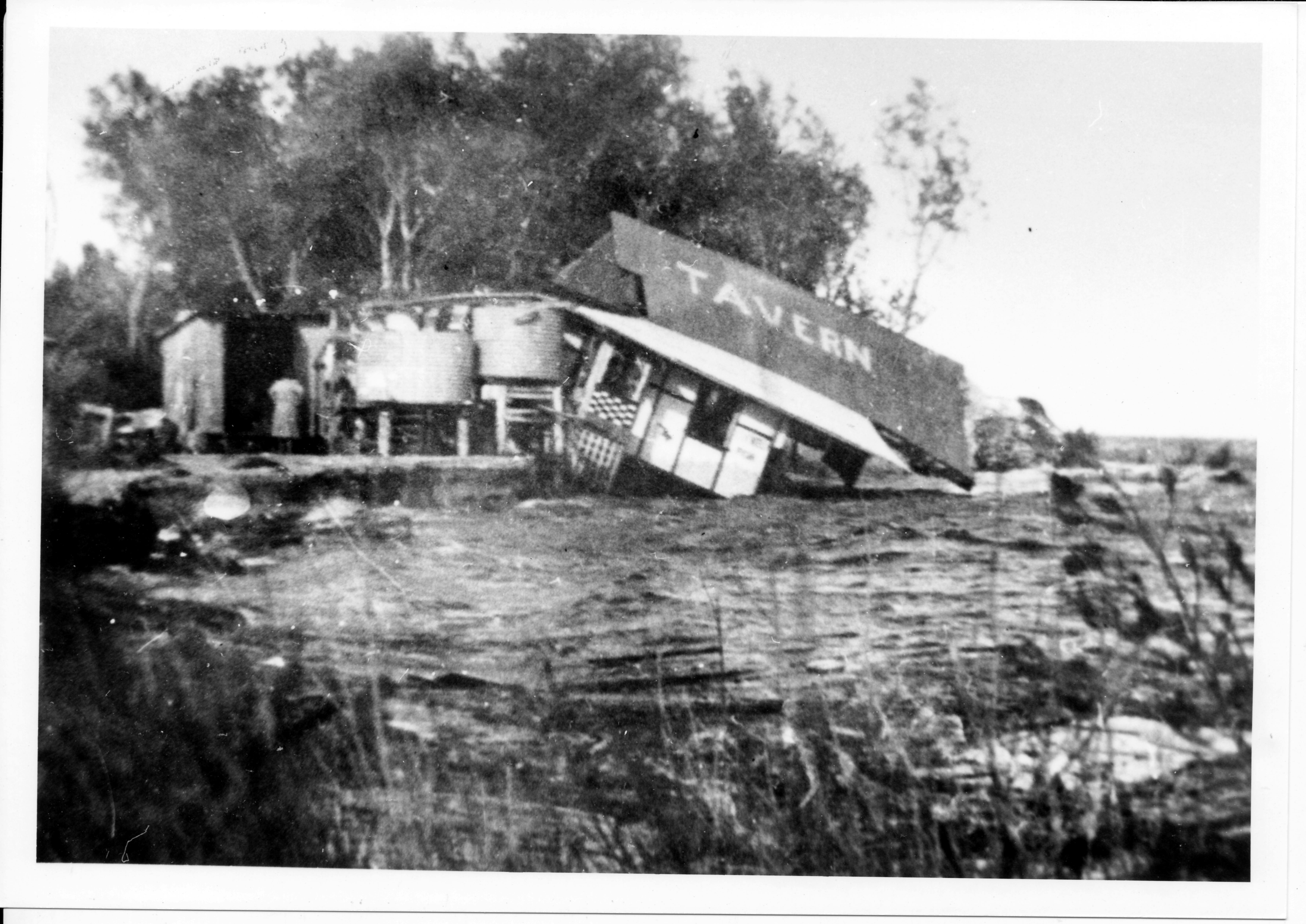
Rock wall collapsing at Amity Point
In January 2011 at Amity Point, a portion of the rock wall collapsed in front of the old school house. Video provided by Konrad Beinssen.
Click here to play video
Rock wall collapsing at Amity Point
In January 2011 at Amity Point, a portion of the rock wall collapsed in front of the old school house. Video provided by Konrad Beinssen.

Key Milestones
-
31 May 2022
-
January 2021
-
July 2020
-
September 2020
-
June 2019

