Coochiemudlo Island Shoreline Erosion Management Plan
Consultation has concluded
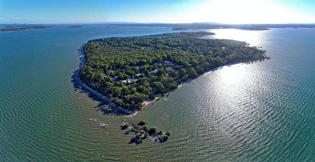
Coochiemudlo Island (Goochie Mudlo) is located off the coast of southeast Queensland in the southern part of Moreton Bay (Quandamooka).
With an emerald fringe of native plants and trees, caves, and beaches, Coochiemudlo Island and surrounding waters are home to an array of wildlife, including migratory shorebirds, dugongs, turtles, dolphins and soldier crabs.
Parts of this small, sub-tropical island, however, are subject to coastal erosion brought on by weather events and storm tide inundation.
Redland City Council, with input from the Community Reference Group (CRG) and other stakeholder groups, has developed a comprehensive plan known as a Shoreline Erosion Management Plan (SEMP) to identify the island's erosion hotspots and recommend the most suitable management options to help protect the island from coastal erosion.
What is the Community Reference Group?
The SEMP's CRG represents a cross-section of the island community and includes representatives from Quandamooka Yoolooburrabee Aboriginal Corporation.
The CRG brings together Traditional Owners and local stakeholders to contribute their local knowledge of erosion, as well as the wider cultural, historical, environmental, and economic values of the island.
This group has contributed by sharing information, insights, and progress reports back to their community networks.
Find out more
- Read the Coochiemudlo Island SEMP located in the 'Documents' section
- Download project fact sheets located in the 'Fact Sheets' section
- Check out the latest project updates
- Learn about other similar projects, like the Coochiemudlo Island SEMP and the Coastal Hazard Adaptation Strategy in the 'Related Projects' section
-
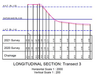
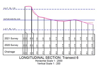
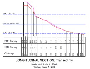
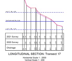
Results of the latest Coochiemudlo Island foreshore survey are in
Share Results of the latest Coochiemudlo Island foreshore survey are in on Facebook Share Results of the latest Coochiemudlo Island foreshore survey are in on X (formerly Twitter) Share Results of the latest Coochiemudlo Island foreshore survey are in on Linkedin Email Results of the latest Coochiemudlo Island foreshore survey are in linkCLOSED: This discussion has concluded.Council recently obtained the results of the latest Coochiemudlo Island beach survey and compared it to the previous year's survey data. A comparison of the beach profiles shows there has not been a significant change to sand levels over the monitoring period, indicating no erosion.
Some movement of sand up and down the beach profile is expected to occur on any natural shoreline, however the survey indicates there has been no net loss of sand and no evidence of erosion over the period.
To view a snapshot of the survey outputs, please refer to the 'Foreshore Survey Results' section located on the main page.
These surveys are providing Council with a good knowledge base to make informed decisions on the management of the foreshore and provide the community confidence that there is no evidence of rampant erosion over the last year.
Council continues to monitor and manage foreshores across Redlands Coast, including Coochiemudlo Island.
Consultation has concludedCouncil recently obtained the results of the latest Coochiemudlo Island beach survey and compared it to the previous year's survey data. A comparison of the beach profiles shows there has not been a significant change to sand levels over the monitoring period, indicating no erosion.
Some movement of sand up and down the beach profile is expected to occur on any natural shoreline, however the survey indicates there has been no net loss of sand and no evidence of erosion over the period.
To view a snapshot of the survey outputs, please refer to the 'Foreshore Survey Results' section located on the main page.
These surveys are providing Council with a good knowledge base to make informed decisions on the management of the foreshore and provide the community confidence that there is no evidence of rampant erosion over the last year.
Council continues to monitor and manage foreshores across Redlands Coast, including Coochiemudlo Island.
-
Council adopts erosion management plan for Coochiemudlo Island
Share Council adopts erosion management plan for Coochiemudlo Island on Facebook Share Council adopts erosion management plan for Coochiemudlo Island on X (formerly Twitter) Share Council adopts erosion management plan for Coochiemudlo Island on Linkedin Email Council adopts erosion management plan for Coochiemudlo Island linkCLOSED: This discussion has concluded.Redland City Council has adopted the Coochiemudlo Island Shoreline Erosion Management Plan (SEMP), which outlines its strategy to manage current and future erosion risks.
Mayor Karen Williams said the development of the SEMP allowed Council to obtain a detailed technical understanding of the island’s coastal processes and opened an avenue for community engagement.
“Importantly, the SEMP recommends a number of management options for Council to protect the sub-tropical island from coastal erosion,” Cr Williams said.
“The principal recommendation is for post-storm beach nourishment across the island to help accelerate the natural recovery process and provide a buffer against future coastal hazards.
“Other recommendations include implementing an ongoing beach monitoring program, vegetation and stormwater management, formalising beach access, and sustainably relocating dredged sand.”
Cr Williams said the formal adoption of the plan followed significant research and consultation with key stakeholders.
“The Coochiemudlo Island SEMP includes input from coastal engineering consultants, a community reference group (CRG) and State Government departments.
“It highlights the underlying causes of shoreline erosion through an assessment of the coastal processes occurring on the foreshore and a consideration of the island’s environmental, cultural and economic values.
“Home to hundreds of residents and an abundance of native wildlife, Coochiemudlo Island is a special part of Redlands Coast and is surrounded by an Emerald Fringe, a natural green belt containing within it woodlands, caves, beaches and wetlands.
“Like all islands, it is subject to shoreline erosion which studies have shown is primarily linked to storm events.”
Division 4 Councillor Lance Hewlett said Council would continue to update the community on the progress of implementing the SEMP’s recommended actions, which remained subject to Council’s annual budget development and budget prioritisation process.
“The adoption of the Coochiemudlo SEMP is a significant milestone,” Cr Hewlett said.
“It will be critical in enabling Council to continue to protect the beauty that is Coochiemudlo Island from coastal hazards.
“The island is the hidden gem of Redlands Coast. The Emerald Fringe is on Council’s schedule of local heritage places, and Norfolk Beach was where Captain Matthew Flinders landed on the island on 19 July 1799 – the first European to do so.
“I would like to thank members of the community reference group, drawn from a cross-section of the island community and representatives from Quandamooka Yoolooburrabee Aboriginal Corporation, for their time and effort throughout the SEMP project.
“Coochiemudlo Island residents have had a fantastic win today, knowing their perspectives have been considered through the representation on this group.”
Consultation has concludedRedland City Council has adopted the Coochiemudlo Island Shoreline Erosion Management Plan (SEMP), which outlines its strategy to manage current and future erosion risks.
Mayor Karen Williams said the development of the SEMP allowed Council to obtain a detailed technical understanding of the island’s coastal processes and opened an avenue for community engagement.
“Importantly, the SEMP recommends a number of management options for Council to protect the sub-tropical island from coastal erosion,” Cr Williams said.
“The principal recommendation is for post-storm beach nourishment across the island to help accelerate the natural recovery process and provide a buffer against future coastal hazards.
“Other recommendations include implementing an ongoing beach monitoring program, vegetation and stormwater management, formalising beach access, and sustainably relocating dredged sand.”
Cr Williams said the formal adoption of the plan followed significant research and consultation with key stakeholders.
“The Coochiemudlo Island SEMP includes input from coastal engineering consultants, a community reference group (CRG) and State Government departments.
“It highlights the underlying causes of shoreline erosion through an assessment of the coastal processes occurring on the foreshore and a consideration of the island’s environmental, cultural and economic values.
“Home to hundreds of residents and an abundance of native wildlife, Coochiemudlo Island is a special part of Redlands Coast and is surrounded by an Emerald Fringe, a natural green belt containing within it woodlands, caves, beaches and wetlands.
“Like all islands, it is subject to shoreline erosion which studies have shown is primarily linked to storm events.”
Division 4 Councillor Lance Hewlett said Council would continue to update the community on the progress of implementing the SEMP’s recommended actions, which remained subject to Council’s annual budget development and budget prioritisation process.
“The adoption of the Coochiemudlo SEMP is a significant milestone,” Cr Hewlett said.
“It will be critical in enabling Council to continue to protect the beauty that is Coochiemudlo Island from coastal hazards.
“The island is the hidden gem of Redlands Coast. The Emerald Fringe is on Council’s schedule of local heritage places, and Norfolk Beach was where Captain Matthew Flinders landed on the island on 19 July 1799 – the first European to do so.
“I would like to thank members of the community reference group, drawn from a cross-section of the island community and representatives from Quandamooka Yoolooburrabee Aboriginal Corporation, for their time and effort throughout the SEMP project.
“Coochiemudlo Island residents have had a fantastic win today, knowing their perspectives have been considered through the representation on this group.”
-
Final SEMP presented to CRG
Share Final SEMP presented to CRG on Facebook Share Final SEMP presented to CRG on X (formerly Twitter) Share Final SEMP presented to CRG on Linkedin Email Final SEMP presented to CRG linkCLOSED: This discussion has concluded.On Wednesday 9 September 2020, Council and project consultant BMT presented the final revised Coochiemudlo Island SEMP to the CRG.
The revised SEMP incorporates feedback received from all project stakeholders, including CRG members.
The next step in the project is to seek support from State Government agencies. Following this period, officers will then present the SEMP to Council for adoption.
Thank you to the CRG for contributing their time and local knowledge to the development of the SEMP.
Consultation has concludedOn Wednesday 9 September 2020, Council and project consultant BMT presented the final revised Coochiemudlo Island SEMP to the CRG.
The revised SEMP incorporates feedback received from all project stakeholders, including CRG members.
The next step in the project is to seek support from State Government agencies. Following this period, officers will then present the SEMP to Council for adoption.
Thank you to the CRG for contributing their time and local knowledge to the development of the SEMP.
-
Draft SEMP presented to CRG
Share Draft SEMP presented to CRG on Facebook Share Draft SEMP presented to CRG on X (formerly Twitter) Share Draft SEMP presented to CRG on Linkedin Email Draft SEMP presented to CRG linkCLOSED: This discussion has concluded.On Tuesday 16 June 2020, project consultant BMT presented the draft Coochiemudlo Island SEMP at a CRG meeting and outlined its recommendations for how erosion can best be managed along the Coochiemudlo Island foreshore.
The meeting, which was facilitated by Council, also provided an opportunity for CRG members to ask questions and discuss BMT's suggestions.
The CRG has been asked to provide feedback on the draft SEMP which will be passed on to BMT for consideration.
The next CRG meeting is planned to be held in the next few months, where BMT will present the final SEMP before it is submitted to Council for review and adoption.
Consultation has concludedOn Tuesday 16 June 2020, project consultant BMT presented the draft Coochiemudlo Island SEMP at a CRG meeting and outlined its recommendations for how erosion can best be managed along the Coochiemudlo Island foreshore.
The meeting, which was facilitated by Council, also provided an opportunity for CRG members to ask questions and discuss BMT's suggestions.
The CRG has been asked to provide feedback on the draft SEMP which will be passed on to BMT for consideration.
The next CRG meeting is planned to be held in the next few months, where BMT will present the final SEMP before it is submitted to Council for review and adoption.
-
CRG meeting update
Share CRG meeting update on Facebook Share CRG meeting update on X (formerly Twitter) Share CRG meeting update on Linkedin Email CRG meeting update linkCLOSED: This discussion has concluded.On Thursday 27 February 2020, Council held this year's first CRG meeting.
The aim of the meeting was so that Council contractors, BMT, could present the draft multi-criteria analysis matrix to CRG members, for review.
The matrix will be used as a tool to review erosion management options in the development of the SEMP.
CRG members provided Council and BMT with valuable feedback on the draft matrix, however, Council is seeking further input from members who were unable to attend the meeting.
BMT also agreed to provide CRG members with an example of how a multi-criteria analysis is undertaken.
Consultation has concludedOn Thursday 27 February 2020, Council held this year's first CRG meeting.
The aim of the meeting was so that Council contractors, BMT, could present the draft multi-criteria analysis matrix to CRG members, for review.
The matrix will be used as a tool to review erosion management options in the development of the SEMP.
CRG members provided Council and BMT with valuable feedback on the draft matrix, however, Council is seeking further input from members who were unable to attend the meeting.
BMT also agreed to provide CRG members with an example of how a multi-criteria analysis is undertaken.
-
Coochie SEMP update
Share Coochie SEMP update on Facebook Share Coochie SEMP update on X (formerly Twitter) Share Coochie SEMP update on Linkedin Email Coochie SEMP update linkCLOSED: This discussion has concluded.On Thursday 1 August 2019, Council facilitated a community reference group meeting in which environmental consultants from BMT presented the draft Shoreline Erosion Study for Coochiemudlo Island.
The study evaluated erosion processes and considered the environmental, social and cultural requirements that subsequently inform the assessment of management options.
These management options are currently being reviewed by Council officers and reference group members.
Consultation has concludedOn Thursday 1 August 2019, Council facilitated a community reference group meeting in which environmental consultants from BMT presented the draft Shoreline Erosion Study for Coochiemudlo Island.
The study evaluated erosion processes and considered the environmental, social and cultural requirements that subsequently inform the assessment of management options.
These management options are currently being reviewed by Council officers and reference group members.
-
Further bathymetric suveys
Share Further bathymetric suveys on Facebook Share Further bathymetric suveys on X (formerly Twitter) Share Further bathymetric suveys on Linkedin Email Further bathymetric suveys linkCLOSED: This discussion has concluded.Due to the shallow nature of the North-eastern portion of the Coochiemudlo Island coastline, previous bathymetric surveys were unable to provide adequate detail. As a result, Council has commissioned further bathymetric surveys which are planned for 25 January 2019, weather permitting.
Consultation has concludedDue to the shallow nature of the North-eastern portion of the Coochiemudlo Island coastline, previous bathymetric surveys were unable to provide adequate detail. As a result, Council has commissioned further bathymetric surveys which are planned for 25 January 2019, weather permitting.
-
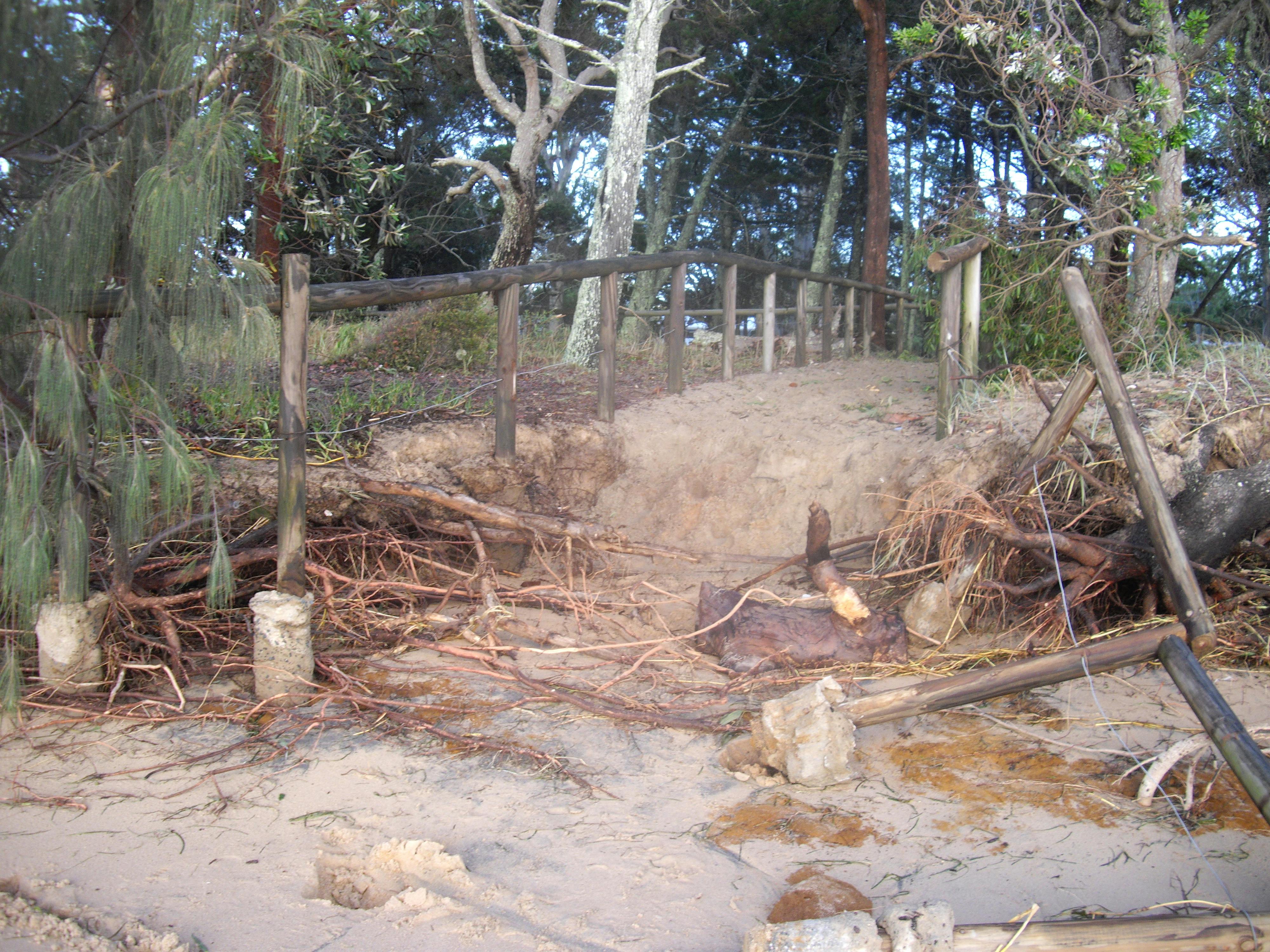
Recent foreshore erosion at Norfolk Beach
Share Recent foreshore erosion at Norfolk Beach on Facebook Share Recent foreshore erosion at Norfolk Beach on X (formerly Twitter) Share Recent foreshore erosion at Norfolk Beach on Linkedin Email Recent foreshore erosion at Norfolk Beach linkCLOSED: This discussion has concluded.Following concerns raised by some Coochie residents regarding the foreshore erosion resulting from wind/tide conditions on 28 November 2018, technical specialists and arborists inspected the site. The arborist’s advice was that while two trees (at Norfolk Beach) and one tree (at Morwong Beach) are at some risk of long term failure, at the time of inspection they displayed typical health, appeared structurally sound and adapted to their immediate environmental conditions. On this basis, officers agreed no stabilisation beach nourishment was required at present. However, Council will continue to monitor the extent of the hazard impact on both trees especially followingContinue reading
Consultation has concludedFollowing concerns raised by some Coochie residents regarding the foreshore erosion resulting from wind/tide conditions on 28 November 2018, technical specialists and arborists inspected the site. The arborist’s advice was that while two trees (at Norfolk Beach) and one tree (at Morwong Beach) are at some risk of long term failure, at the time of inspection they displayed typical health, appeared structurally sound and adapted to their immediate environmental conditions. On this basis, officers agreed no stabilisation beach nourishment was required at present. However, Council will continue to monitor the extent of the hazard impact on both trees especially following the king tides in the near future. BMT, the coastal experts commissioned to complete the Coochie SEMP, also advised they did not support limited beach nourishment as a method to support vulnerable trees.
In the long term, the SEMP management options will address environmental, social, cultural and economic values of the foreshore at Norfolk Beach.
In addition, I will discuss potential indigenous cultural heritage values associated with the vulnerable trees with QYAC.
-
Site inspection - 8 October 2018
Share Site inspection - 8 October 2018 on Facebook Share Site inspection - 8 October 2018 on X (formerly Twitter) Share Site inspection - 8 October 2018 on Linkedin Email Site inspection - 8 October 2018 linkCLOSED: This discussion has concluded.Jessie and Malcolm, our consultants from BMT, were out at Coochiemudlo Island on Monday 8 October for an inspection at low tide.
All the beaches were inspected - from the golf course beach around to Morwong Beach. The purpose of the low tide inspection was to identify the location of inter-tidal reefs and rocky control points, and well as locations where the seaward extent of sand is limited. The accretion of sand onto the eastern beaches was noted. The previous high tide mark and historic erosion scarps were clearly visible and therefore any future site inspections will likely be laterContinue reading
Consultation has concludedJessie and Malcolm, our consultants from BMT, were out at Coochiemudlo Island on Monday 8 October for an inspection at low tide.
All the beaches were inspected - from the golf course beach around to Morwong Beach. The purpose of the low tide inspection was to identify the location of inter-tidal reefs and rocky control points, and well as locations where the seaward extent of sand is limited. The accretion of sand onto the eastern beaches was noted. The previous high tide mark and historic erosion scarps were clearly visible and therefore any future site inspections will likely be later in the study and related to specific issues.
-
Update - October 2018
Share Update - October 2018 on Facebook Share Update - October 2018 on X (formerly Twitter) Share Update - October 2018 on Linkedin Email Update - October 2018 linkCLOSED: This discussion has concluded.Since forming the Coochie Shoreline Erosion Management Plan (SEMP) Community Reference Group (CRG) in October 2017, the group has met five times bringing community perspectives to the table. The reference group was able to have input into the specifications and the appointment of consultants, BMT who were commissioned to complete the SEMP in July 2018. BMT are experienced in Coochiemudlo’s erosion issues having authored the Norfolk Beach Shoreline Erosion Study though their focus is now broader, encompassing the whole island. The first and current stage in the process involves BMT carrying out research into current literature, coastal processes impacting CoochieContinue reading
Consultation has concludedSince forming the Coochie Shoreline Erosion Management Plan (SEMP) Community Reference Group (CRG) in October 2017, the group has met five times bringing community perspectives to the table. The reference group was able to have input into the specifications and the appointment of consultants, BMT who were commissioned to complete the SEMP in July 2018. BMT are experienced in Coochiemudlo’s erosion issues having authored the Norfolk Beach Shoreline Erosion Study though their focus is now broader, encompassing the whole island. The first and current stage in the process involves BMT carrying out research into current literature, coastal processes impacting Coochie and identifying risks. To that end, an Open Day was recently held on Coochie to enable locals and landowners the opportunity to provide their input into areas that are subject to erosion, as well as identifying areas of value to the local community.
Coochiemudlo Island Erosion
Key Milestones
-
February 2021
-
June 2020
-
August 2019
-
October 2018